| RSS | EN | DE | EL | ES | FR | IT | RU

Batu Tara Volcán

Updated: 2 jul. 2026 01:04 GMT -
Stratovolcano
Sunda Islands, Indonesia, -7.79°S / 123.58°E
Summit height: 748 m / 2,454 ft
Current status: normal or dormant (1 out of 5)
Last update: 27 may 2022 (Smithsonian / USGS Weekly Volcanic Activity Report)
Strombolian activity from Batu Tara volcano - the "Stromboli" of the Flores Sea

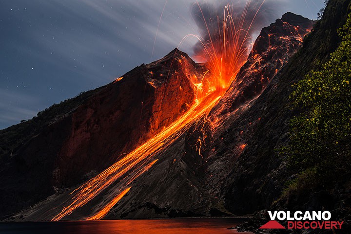
Batu Tara is a small island volcano 50 km north of Lembata Island in the Flores Sea. It is frequently active, producing spectacular strombolian explosions with abundant incandescent bombs and ash plumes rising to hundreds or few kilometers elevation.

[smaller] [larger]
Typical eruption style: Explosive
Erupciones del volcán Batu Tara: 2007-2011 (Oct), 2006, 1852

Latest nearby earthquakes

Fecha y horaMag / Prof.Distancia / Ubicación
19 jun 06:21 (GMT +8)
2.7

233 km
18 km al este Mar de Banda, 77 km al noreste de Lewoleba, Indonesia Más

Background

Batu Tara island is the top of a larger stratovolcano, its base reaching 3000 meters below sea level. It has a large central summit crater of 900 x 700 meters diameter open to the east.
The scar on its eastern side is a flank collapse feature similar to the Sciara del Fuoco of Italy's Stromboli volcano. Vegetation covers the flanks of Batu Tara to within 50 m of the 748-m-high summit.

Batu Tara lies on young and thin oceanic crust north of the main volcanic Sunda-Banda Arc at the boundary of the collision of the north moving Australian with the Sunda tectonic plate. Geochemically, it is noted its potassic leucite-bearing basanitic and tephritic rocks.

Eruptions from Batu Tara
Until 2006, the only confirmed historical eruption from Batu Tara were during 1847-52, which produced explosions with volcanic bombs and a lava flow.
On July 1st, 2006, Batu Tara was observed erupting again. An ash plume rose to 5000 ft (ca 2 km). Since then, it has been erupting frequently. Most eruptions were strombolian or vulcanian type, with explosions producing ash plumes of 1-2 km, similar to Anak Krakatau's activity.
In March 2007, a phase of stronger eruptions promted the evacuation of 15000 people from Lembata Island nearby.

Batu Tara Volcano Photos

Erupciones volcánicas significativas: Batu Tara volcano

In the past 10,000 years, Batu Tara has had at least 2 confirmed eruptions, all documented by historical records or observations.
Additionally, there are 2 uncertain or discredited eruptions from Batu Tara volcano.
The table below lists all known eruptions (date in bold face) of Batu Tara volcano in historic times and during the past 10,000 years. Updates on the most recent volcanic activity of Batu Tara can be found on the news page of Batu Tara volcano.
FechaNotaVEIFallecidosDaños
?? 2022 ene 31
Erupción incierta
Obs. históricas/documentos
?
desconocido
2007 ene 17 ? - 2015 nov 26
Obs. históricas/documentos
2
desconocido
?? 2006 jul 1
Erupción incierta
1?
desconocido
1847 - 1852 ago 31 o después
Obs. históricas/documentos
2
desconocido
Remark:
Our list of volcanic eruptions closely follows the database of eruptions of the Smithsonian's Global Volcanism Project (GVP), the internationally most recognized data source for volcanic eruptions, but also includes significant eruptive episodes or related volcano events. "Volcanic eruptions" are usually to be understood as sequences of individual eruptive episodes that can follow each other, or even overlap (if several vents are involved), and can last many years, decades or even longer. For example, the current activity of Stromboli volcano is understood as a single eruption that has been ongoing since 1934.
Fuentes: NOAA National Centers for Environmental Information (NCEI), Global Significant Volcanic Eruptions Database. doi:10.7289/V5TD9V7K | Global Volcanism Project / Smithsonian Institution

Batu Tara Volcano FAQ

+When was the last eruption of Batu Tara volcano?

+How often does Batu Tara volcano erupt?

+How active is Batu Tara volcano at present?

+When was the largest eruption of Batu Tara volcano?

Últimas imágenes satelitales

BatuTara imagen satelital sat1BatuTara imagen satelital sat2

Batu Tara Volcán Mapas

Below is a selection of maps showing the location and surroundings of the volcano at various resolutions based on aerial-imagery / terrain maps. Feel free to use them for non-commercial purposes on your blog or website as long as you credit them with a link back to this page (click to copy it).
Satellite/aerial-type map of Batu Tara volcano (world scale)
Terrain-type map of Batu Tara volcano (world scale)
Satellite/aerial-type map of Batu Tara volcano (region scale large)
Terrain-type map of Batu Tara volcano (region scale large)
Satellite/aerial-type map of Batu Tara volcano (region scale medium)
Terrain-type map of Batu Tara volcano (region scale medium)
Satellite/aerial-type map of Batu Tara volcano (region scale small)
Terrain-type map of Batu Tara volcano (region scale small)
Satellite/aerial-type map of Batu Tara volcano (local scale large)
Terrain-type map of Batu Tara volcano (local scale large)
Satellite/aerial-type map of Batu Tara volcano (local scale medium)
Terrain-type map of Batu Tara volcano (local scale medium)
Satellite/aerial-type map of Batu Tara volcano (local scale small)
Terrain-type map of Batu Tara volcano (local scale small)
Satellite/aerial-type map of Batu Tara volcano (scale of 10s of km)
Terrain-type map of Batu Tara volcano (scale of 10s of km)
Satellite/aerial-type map of Batu Tara volcano (scale of 20-40 km)
Terrain-type map of Batu Tara volcano (scale of 20-40 km)
Satellite/aerial-type map of Batu Tara volcano (scale of approx. 10-20 km)
Terrain-type map of Batu Tara volcano (scale of approx. 10-20 km)
Satellite/aerial-type map of Batu Tara volcano (scale of 5-10 km)
Satellite/aerial-type map of Batu Tara volcano (scale of few kilometers)
Volcanoes & Earthquakes - app for Android
Guaranteed tours
2-18 ago 2026: From Krakatau to Bali - Java (Indonesia)
14-30 ago 2026: Volcanoes and Spices - Halmahera N-Sulawesi (Indonesia)
19 sep - 3 oct 2026: Green Volcanoes - Azores (Portugal)
5-21 oct 2026: From Krakatau to Bali - Java (Indonesia)
11-27 oct 2026: From Bali to Flores - Java (Indonesia)
6-22 nov 2026: Volcanoes and Spices - Halmahera N-Sulawesi (Indonesia)
26 may - 6 jun 2027: Land of History - Armenia
= spaces available   = guaranteed   = few spaces left   = booked out

Batu Tara volcano (Komba Island) - Smithsonian / USGS Weekly Volcanic Activity Report for 27 April-3 May 2022 (New Activity / Unrest)

Thursday, May 5, 2022 | 4 years ago · VN
PVMBG issued VONAs noting recent increased gas emissions at Batu Tara but no confirmed eruptions. Ground-based observers reported that at 1453 and 1617 on 28 April gas emissions rose 1-1.2 km above the summit and drifted W. At 0054 on 2 May gas emissions rose 500 m and drifted W.
The Alert Level rema…

En esta página:

Try our free app!
Volcanoes & Earthquakes - new app for Android
Android | iOS version

More on VolcanoDiscovery

Why is there advertising on this site?

¡Apóyanos – Ayúdanos a mejorar nuestros servicios!

Nos encanta trabajar para traerte los datos más recientes sobre volcanes y terremotos de todo el mundo, solo para ti. Sin embargo, mantener nuestro sitio web y nuestras aplicaciones gratuitas requiere mucho tiempo, esfuerzo y recursos.
Tu apoyo nos permite ampliar la capacidad de nuestro hardware y software, así como fortalecer a nuestro equipo editorial. Nuestra misión es ofrecer actualizaciones continuas en tiempo real siempre que ocurra un terremoto o una erupción volcánica — ¡y tus donaciones lo hacen posible! Cada contribución, grande o pequeña, es profundamente apreciada. Si encuentras útil la información que ofrecemos y deseas ayudarnos a integrar nuevas funciones, crear contenido atractivo y mejorar nuestra tecnología, por favor considera hacer una donación:

Usa PayPal:

Funciones planeadas:

Gracias a tus donaciones anteriores, recientemente hemos añadido:
Descarga la app Volcanes & Terremotos para ser de los primeros en recibir alertas rápidas en línea sobre terremotos y volcanes:
Android | iOS
¡Gracias por formar parte de nuestra misión!
Sources: VolcanoDiscovery / VolcanoAdventures and other sources as noted.
Use of material: Most text and images on our websites are owned by us. Re-use is generally not permitted without authorization. Contact us for licensing rights.
Volcanoes & Earthquakes
VolcanoDiscovery Home
Volcanes | Sismos | Fotos | News | | Shop | App
Adventure & Study Travel
Tours to Volcanoes and Volcanic Areas: walking tours, photo tours, study tours
Tours & Dates | FAQ | About us
Get our newsletter!
Company info
Contact | Legal info | Terms & conditions
Follow us
Follow us on facebook Follow us on Instagram Follow us on Bluesky Follow us on Twitter Visit our Youtube channel
EN | DE | EL | ES | FR | IT | RU
VolcanoDiscovery GmbH, Germany, Reg. nr.: HRB 103744, EU Tax Id: DE 297 465 123 owned and created by
Dr. Tom Pfeiffer, volcanologist, volcano photographer, tour organizer member of
IAVCEI
IAVCEI
Vulkanologische Gesellschaft
Volcanological Society
Ecotourism Greece
Ecotourism Greece
RUV insurance
Insured by R+V
VolcanoDiscovery © 2004- All Rights Reserved | Privacy - Cookie Settings